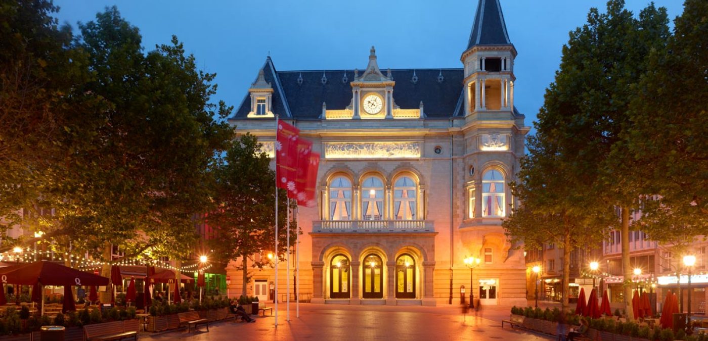
Luxembourg, Luxembourg

Registration Year

1994

Registered Sector

City of Luxembourg: its Old Quarters and Fortifications

Historical Function

Military.

Administrative Status

Capital of the Grand Duchy of Luxembourg.

Mayor of Luxembourg

Xavier Bettel

Photos

Luxembourg: Le viaduc "Pulvermuhle"Luxembourg: Centre Culture de Rencontre de NeumünsterLuxembourg: Centre Culture de Rencontre de NeumünsterLuxembourg: Faubourg du GründLuxembourg: Faubourg du GründLuxembourg: Faubourg du GründLuxembourg:Luxembourg: Batiment Robert KriepsLuxembourg: Rocher du BockLuxembourg: Centre Culture de Rencontre de NeumünsterLuxembourg: Faubourg du GründLuxembourg: CornicheLuxembourg: vue sur les Trois ToursLuxembourg-centre: Place Guillaume II, statue équestre Guillaume II et vue sur le Palais Grand-DucalLuxembourg- vieille ville: Vue sur la Vallée de l'Alzette, l'ancienne Abbaye de Neumünster, le rocher du Bock et les jardinsLuxembourg: Vieille ville, ancienne tourrette espagnole,Luxembourg: Quartier du Kirchberg et Musée d'Art Moderne Grand-Duc Jean MUDAMLuxembourg-centre : Marché sur la place Guillaume IILuxembourg-centre: Place Guillaume II, statue équestre Guillaume II et marché aux fleursLuxembourg: Vieille ville, Terrasse au bord du fleuve de l'Alzette dans le quartier du Grund10Luxembourg, place de l'Europe avec vue sur la Philharmonie LuxembourgLuxembourg: panorama sur ville-forteresse et vieille ville depuis le plateau du RhamLuxembourg: panorama sur le chemin de la Corniche depuis le plateau du RhamLuxembourg: vue sur les murs de la forteresse et le Chemin de la CornicheLuxembourg: Balade sur le chemin de la Corniche, sur les mues de la forteresse (UNESCO)Luxembourg: panorama sur ville-forteresse et vieille ville, classée UNESCOLuxembourg: Festival Blues'n Jazz Rallye mi-juillet: chaque année 25.000 fans de musique se pressent dans les faubourgs du Grund et Clausen pour écouter 50 concerts gratuits Les scènes en plein air sont nichées au pied de la forteresse UNESCO, et jouissenLuxembourg: Festival Blues'n Jazz Rallye mi-juillet: vue sur le faubourgs du Grund et le parvis de l'Abbaye de NeumünsterLuxembourg - centre: Les festival de musique "MeYouZik" et "Rock um Knuedler" font vibrer chaque été 15.000 fans de musique rock et world sur la place GuillaumeII, en plein centre-ville.

Location and site

The city of Luxembourg is located in the central southern part of the country of the same name, not far from the Belgian, German and French borders. It is crossed by the Pétrusse and Alzette rivers, which meander around its principal promontories, the Rocher du Bock and the Plateau du Rham.

Historical Reference

  • A castle stronghold erected by the Count Sigefroid on the Rocher du Bock dates to the origin of the city in 963. In the later years of the Roman Empire (late 4th century and early 5th century), a fortification occupied this same site, which was close to the intersection of two Roman roads.
  • Urban expansion necessitated the construction of a second fortification wall at the end of the 12th century. A third wall, known as the Wenceslas Wall, was erected in the 15th century to integrate the Plateau du Rham and, in the lower town, the Grund quarter.
  • The fortress of Luxembourg was coveted. After it was incorporated into the Circle of Burgundy of Charles-Quint during the 16th century, the country was involved in conflicts involving, among others, the House of Burgundy, the House of Habsburg, Napoleon III and Bismark's Prussia.
  • Under its foreign rulers, the defense system of the city was reinforced and developed in four stages. The Spanish (1671-1684), the French under the direction of Vauban (1684-1697), the Austrians (1715-1795), and the Prussian garrison as part of the German Confederation (1815-1867) participated in the creation of this fortified ensemble.
  • In 1867, the signing of the Treaty of London led to the stipulation that the Grand Duchy would remain neutral in perpetuity. Shortly afterwards, the fortress was evacuated and the defense system was for the most part dismantled. The extent of the fortifications had reached 180 hectares, and the city was 120 hectares in area.

Urban Morphology

The site includes the upper city and the lower city which developed around the deep valley of the Alzette and Pétrusse rivers. The Chemin de la Corniche follows the edge of the escarpment, overlooking the meandering river that dictated the layout of adjacent roads. Bridges and viaducts straddle the valley, linking different parts of the city. The network of roads, which was influenced by military planning, has been preserved. Numerous views may be enjoyed from the valley and the upper parts of the city.

Within this uniform urban ensemble, the military architecture which remains - bastions, towers, barracks, forts, and vestiges of locks - still evokes the force of the site over the course of its history. Linked to the natural landscape, the rich architectural panorama of Luxembourg is dominated by the 17th-century Church of St-Michel and the spires of the 17th-century cathedral of late Gothic expression. On the Chemin de la Corniche, as in the valley, the houses line the curve of the river.

Registration Criteria

"The fortress city of Luxembourg played a significant role in the history of Europe for several centuries. It preserves major remains of its impressive fortifications and its old quarters, in an exceptional natural setting." (IV)

Contact

Monsieur Xavier Bettel
Député-Maire
Hôtel de ville
42, place Guillaume II
Luxembourg, Grand Duché du Luxembourg
Tel:
+352 4796.2674
Fax:
+352 22 74 99
Email:
bettel@vdl.lu
Monsieur Patrick Sanavia
Directeur
Service des Sites et Monuments Nationaux
26, rue Münster
Luxembourg, Grand Duché de Luxembourg
Tel:
+352 247 86650
Fax:
+352 46 17 79
Email:
patrick.sanavia@ssmn.etat.lu
Madame Martine Vermast
Architecte-directeur
Administration communale
3, rue du Laboratoire
Luxembourg, Grand Duché de Luxembourg
Tel:
+352 47962850
Fax:
+352 4796 4789
Email:
mvermast@vdl.lu